How Do You Try the Flight Simulator in Google Earth and Fly Around the World?
For decades, human beings have dreamed of soaring above the clouds, looking down at the intricate tapestry of rivers, mountains, and urban landscapes. While commercial aviation allows us to peer through a small oval window, virtual simulation brings the entire globe directly to our fingertips. One of the most remarkable, yet frequently overlooked, features hidden within desktop software is the built-in flight simulator in Google Earth. It transforms a global mapping application into a fully functional 3D aerodynamic playground.
Whether you want to glide over the peak of Mount Everest, trace the winding path of the Amazon River, or execute a perfect landing at Heathrow Airport, this hidden gem offers an accessible entry point into aviation enthusiasts’ dreams. In this comprehensive guide, we will explore exactly how to access, control, and master the flight simulator in Google Earth to seamlessly fly around the world.
1. What is the Hidden Flight Simulator in Google Earth?
Before diving into the cockpit, it is essential to understand what makes this feature so unique. Originally introduced as a hidden “Easter egg” in Google Earth desktop versions years ago, the flight simulator has evolved into a beloved stable feature. It utilizes the platform’s massive database of satellite imagery, 3D digital elevation models, and rendered structural topology to create a surprisingly realistic backdrop for flight.
Unlike complex, standalone retail simulators that require massive installation files and dedicated graphics engines, the flight simulator in Google Earth streams geographic data directly over the internet. This allows users with standard computers to pilot an aircraft across thousands of miles without exhausting local storage capacity. It serves as an excellent educational tool, a casual pastime, and a fascinating way to conceptualize global geography from a pilot’s perspective.
2. Step-by-Step Guide to Launching the Simulator
To begin your aerial journey, you must use the desktop application version, known as Google Earth Pro, which is free to download for Windows, macOS, and Linux. The web-based or mobile app versions do not currently support the full-featured flight simulation mode.
The Keyboard Shortcut Method
-
Launch Google Earth Pro on your desktop computer.
-
Wait for the global map to load fully.
-
Press the following key combination based on your operating system:
-
Windows: Press
Ctrl+Alt+Asimultaneously. -
Mac: Press
Cmd+Opt+Asimultaneously.
-
The Application Menu Method
If the keyboard shortcut does not activate the prompt, you can launch it manually via the user interface:
-
Navigate to the top menu bar and click on Tools.
-
From the drop-down menu, select Enter Flight Simulator.
Selecting Your Aircraft and Starting Position
Once triggered, a configuration window will appear presenting two distinct choices:
-
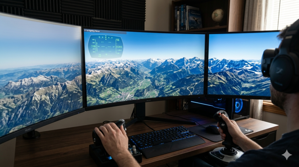
F-16 Fighting Falcon: A high-performance military jet capable of extreme speeds and nimble maneuvers. It is ideal for experienced users who want to cover vast geographic areas quickly, though its sensitive handling makes landing difficult for beginners.
-
Cirrus SR22: A single-engine propeller aircraft designed for general aviation. It moves at a much slower, manageable pace, making it perfect for sightseeing, low-altitude exploration, and learning basic flight mechanics.
Next, choose your Starting Position. You can select a current view on your map or choose from a long list of international airports complete with accurate runway alignments. Click Start Flight to enter the cockpit view.
3. Mastering the Flight Controls: Keyboard, Mouse, and Joystick
When you first enter the simulator, you will see a Head-Up Display (HUD) overlaid on the world map. Understanding this interface is vital to keeping your aircraft stable and preventing catastrophic nose-dives.
The Head-Up Display (HUD) Breakdown
-
Speed (Knots): Displayed on the left side of the screen, showing your current forward velocity.
-
Heading: The compass degree indicator at the top of the interface.
-
Pitch Angle: The horizontal ladder lines in the center indicating the degree of climb or descent relative to the horizon.
-
Altitude (Feet): Displayed on the right side, showing your height above mean sea level.
Using a Mouse or Joystick
To fly using a mouse, left-click once in the center of the screen. Your cursor will transform into a small plus sign (+). Moving the cursor away from the center controls the pitch and roll. To regain control of your standard mouse cursor at any time, simply right-click.
For maximum realism, the simulator automatically detects compatible USB flight sticks and controllers. If you are building a dedicated multi-display entertainment desk, incorporating a premium steering setup or a mobile triple screen setup simracing array can enhance your peripheral vision when utilizing custom camera views across multiple system monitors.
4. Flight Simulator in Google Earth vs. Traditional Flight Simulators
To understand where this tool fits within modern computing, it is useful to weigh its practical advantages against dedicated software alternatives like Microsoft Flight Simulator or X-Plane.
Benefits
-
Zero Cost: Google Earth Pro is completely free, offering global high-resolution coverage without subscription fees.
-
Instant Accessibility: It operates smoothly on mid-tier laptops and business computers without requiring expensive gaming graphics cards.
-
Unmatched Geography: It leverages real-world satellite mapping, meaning local landmarks, houses, and topographical contours match actual global coordinates precisely.
Drawbacks
-
Basic Physics Engine: The aerodynamic modeling is rudimentary; it lacks realistic crosswinds, thermal dynamics, turbulence, and true-to-life stalls.
-
No Cockpit Graphics: There are no rendered 3D dials, switches, or interactive instrument panels; all data is fed through a minimalist HUD.
-
No Active Traffic: You will not encounter real-time air traffic control or other online pilots sharing the sky with you.
5. Strategic Tips for Smooth Global Exploration
Flying thousands of feet in the air across dynamic terrain requires preparation. Use these expert tips to maximize visual quality and avoid system crashes during long cross-country flights:
1. Optimize Your Cache Settings
Streaming entire continents in 3D puts heavy demands on your system memory. Go to Tools > Options > Cache and maximize both the memory cache size and disk cache size. This ensures that ground details load rapidly beneath your wings, preventing blurry textures.
2. Choose the Right Aircraft for the Destination
If you are planning to navigate the narrow crevices of the Grand Canyon, choose the Cirrus SR22. Its slower cruise speed gives the 3D imagery plenty of time to buffer and render. Save the F-16 for high-altitude oceanic crossings or swift continental transitions.
3. Take Advantage of Space Bar Pauses
If you get disoriented, start spinning out of control, or simply want to stop and look at a famous landmark below, press the Spacebar. This freezes your flight mid-air, allowing you to study your coordinates, clear your head, or take screenshots before resuming.
6. How to Gracefully Land Your Aircraft
Taking off in the flight simulator in Google Earth is simple—just max out your thrust and pull back gently on the controls. Landing, however, requires patience, precision, and careful speed management.
Step 1: Align Your Flight Path
Locate an airport using the starting position menu or find a long, flat stretch of terrain. Line up your aircraft’s heading with the center line of the runway from several miles away.
Step 2: Manage Your Speed
Reduce your engine thrust by tapping Page Down repeatedly. If you are flying the Cirrus SR22, keep your speed dropped down to around 70–90 knots. For the F-16, you will need to maintain a higher velocity to avoid stalling, targeting roughly 140–160 knots.
Step 3: Extend Your Flaps
Press F to extend your wing flaps. Flaps increase lift at lower speeds, allowing your aircraft to remain stable as you decelerate toward the runway surface.
Step 4: Touch Down and Apply Brakes
Level off your pitch so that your wheels touch the ground parallel to the runway surface. The moment your landing gear makes contact, press Page Down to kill the engine thrust completely, and hold down the B key to apply the wheel brakes until the aircraft comes to a complete halt.
7. Troubleshooting Common Flight Anomalies
Sometimes, flights do not go exactly as planned. If you experience performance issues, here are quick solutions to common errors:
-
The Ground Looks Flat: Ensure that the “3D Buildings” and “Terrain” layers are checked in the lower-left sidebar menu of Google Earth Pro. Without these active, cities and mountains will appear flat.
-
The Controls are Too Sensitive: If tapping a key sends your jet into a violent spin, try switching to mouse control by clicking on the screen. The mouse allows for smaller, incremental adjustments.
-
The Software is Lagging: Lower your application’s resolution or graphics rendering settings under the preferences menu, and ensure no heavy background downloads are running on your internet connection.
If you enjoy configuring complex hardware arrays to complement your exploration, or if you run into physical computer issues while trying to get your peripherals working properly, accessing technical repair resources like the comprehensive troubleshooting guides found on iFixit can assist in keeping your hardware in peak operating condition.
8. Exploring Alternative Tech Options: Best Phone Under 20000
While exploring the world from a desktop computer offers an immersive experience, many users prefer to track their travel routes, research aviation coordinates, or manage secondary simulation apps via affordable mobile devices. For budget-conscious tech enthusiasts seeking an excellent secondary device, finding the best phone under 20000 provides an exceptional balance of processing power, clear display resolution, and long-lasting battery life.
These affordable smartphones deliver impressive multi-core performance capable of running mobile companion maps and aviation calculation apps effortlessly. When searching for the best phone under 20000, prioritize models with at least 6GB of RAM and crisp Full HD+ displays to easily read micro-text map coordinates. Furthermore, tracking down the best phone under 20000 with a high-capacity 5,000mAh battery ensures your device stays powered during extended virtual cross-country flights.
Many modern devices highlighted as the best phone under 20000 feature brilliant high-refresh-rate panels, which make scrolling through dense geographic data look incredibly fluid. Ultimately, pairing your desktop simulation setup with the best phone under 20000 creates an efficient, cost-effective digital environment for all your technological and exploratory interests.
9. Expanding Your Flight Experience Globally
Once you have mastered the basics of takeoff, flight stabilization, and landing, the entire world opens up to exploration. Here are several iconic routes and destinations worth visiting to truly test your skills:
-
The Swiss Alps: Navigate through jagged snow-capped peaks and deep valleys using the nimble handling of the Cirrus SR22.
-
New York City: Fly low along the Hudson River and weave between beautifully rendered 3D skyscrapers, historical bridges, and monuments.
-
The Pyramids of Giza: Discover historical landmarks by typing their coordinates into the Google Earth search bar before launching the flight simulator.
To deepen your understanding of digital cartography, flight dynamics, and the history behind this software, explore external reference materials on the Google Earth Wikipedia Page. There, you can learn about the engine’s evolution from its early days as EarthViewer 3D to its current globally recognized form.
Conclusion
The hidden flight simulator in Google Earth provides a fantastic, cost-free gateway into the world of aviation and geographical exploration. By mastering simple keyboard shortcuts, configuring your HUD preferences, and choosing the right aircraft for your journey, you can seamlessly pilot your way across any destination on earth. From casual sightseeing to perfecting difficult runway landings, this integrated feature remains one of the best educational tools hidden right on your desktop computer.
Take the time to adjust your system cache settings, fine-tune your peripheral controllers, and enjoy the breathtaking views from your virtual cockpit. Just as managing modern digital devices requires proper hardware maintenance and smart printer subscription management, maintaining your virtual flight system ensures a smooth, crash-free journey around our magnificent planet. Happy flying!
Related posts:
![How to fix Google Messages landscape layout issues on Android phone]()
How to Fix Google Messages Landscape Layout Issues on Android Phone?
![fix 403 forbidden error on Google Chrome ifixit.org.uk]()
How to Fix 403 Forbidden Error on Google Chrome: The Complete Troubleshooting Guide
![Microsoft Surface Laptop 3 Screen Crack: ifixit.org.uk]()
Microsoft Surface Laptop 3 Screen Crack: Comprehensive Guide to Causes, Repair Options, and Preventi...
![Why Won’t macOS Golden Gate 27 Beta Install in a Virtual Machine]()
Why Won’t macOS Golden Gate 27 Beta Install in a Virtual Machine?
![How to Fix Google Chrome Not Updating on Older Macs]()
How to Fix Google Chrome Not Updating on Older Macs (2026 Complete Guide)
![How to Screenshot on Mac: The Ultimate Guide to Keyboard Shortcuts & Hidden Features]()
The Ultimate Guide on How to Screenshot on Mac: Shortcuts, Tips, and Hidden Utilities
![How to Fix mds_stores High Memory and CPU Usage on Mac]()
How to Fix mds_stores High Memory and CPU Usage on Mac
![How to Install macOS Golden Gate 27 Beta on Your Mac]()
How to Install macOS Golden Gate 27 Beta on Your Mac?